Restructuring
OZ URBANISM

More information

Restructuring
OZ URBANISM

More information

Our urban development projects focus on generating social and economic opportunities. The urban environment is improving and there is a greater interaction between living, learning, working and recreation. Our urban developers work on strategic visions, spatial transformations, urban restructuring, city centre plans, site division, and participation trajectory. Restructuring is a catalyst for further development in the project area. Restructuring is multifaceted. We connect routes and functions in an industrial or residential area, integrate a historic environment with new construction, and give existing functions a boost. Our step-by-step plan to successful restructuring entails: we exploring the location and context, we enter into discussions with stakeholders and advisers then create an urban master plan, design, or vision to get started. We work both independently, as well as but often also together with other design agencies or consultants, such as landscape architects. Our designs are always in balance: between what is possible spatially on the one hand, and on the other, appropriate to the needs of our client.
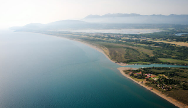
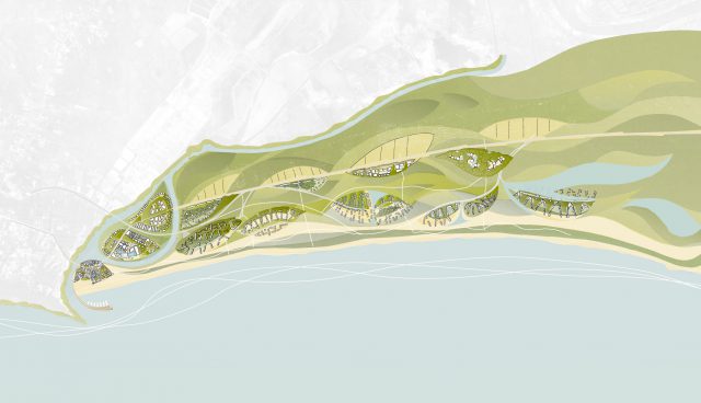
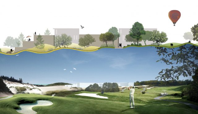
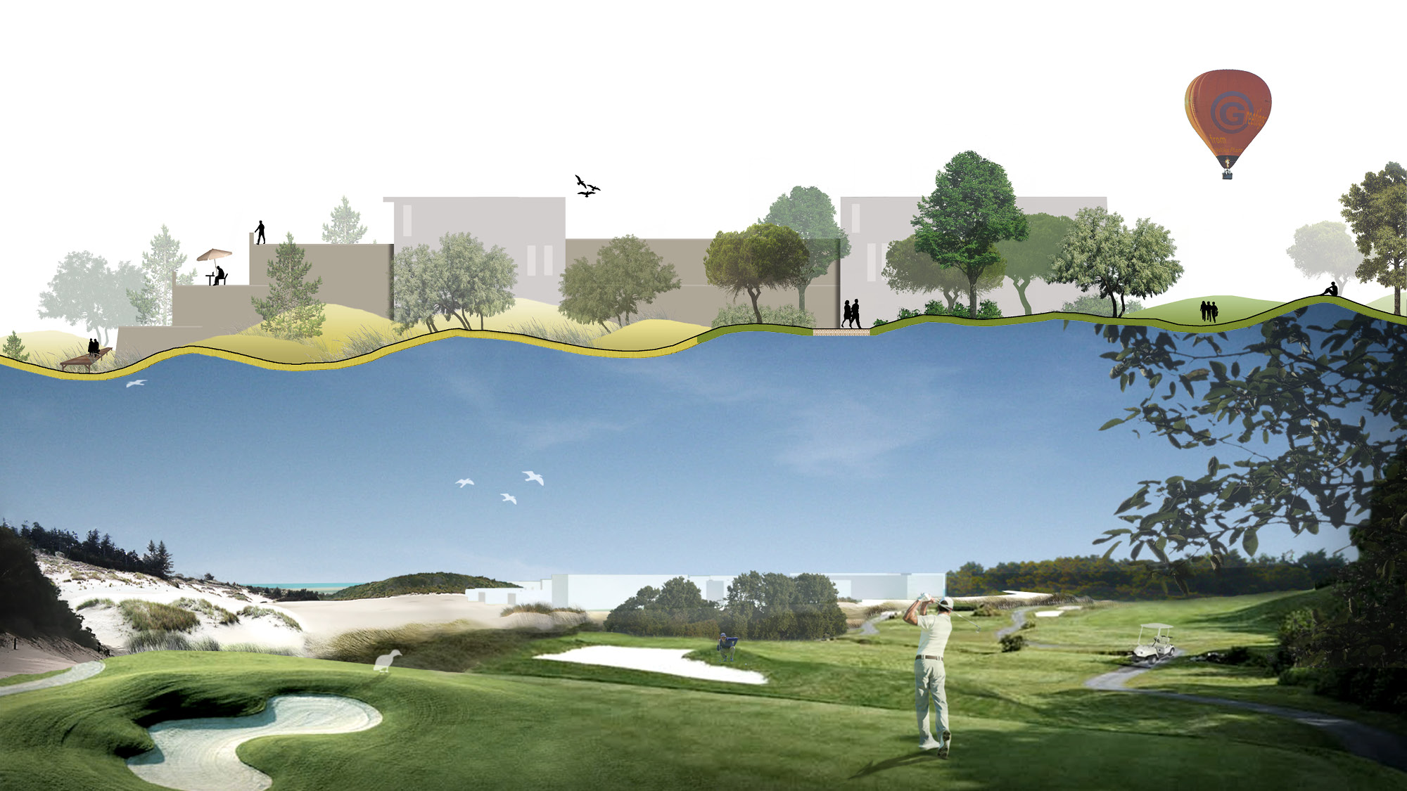
Velika Plaza Ulcinj, Montenegro / design by OZ Amsterdam

VELIKA PLAZA MONTENEGRO

The Montenegrin Ministry for Economic Development set up a competition for the sustainable development of the coastal strip Velika Plaža into a tourist waterfront in 2007. Velika Plaža is located in an ecological zone on the Adriatic Sea. Along with Stijlgroep Landschap and Stedelijke Ruimte Rotterdam, OZ was responsible for the landscape design consisting of 13 “islands” integrated into the existing environment.

10 principles for the design:

1. Retain, reinforce and expand the authentic atmosphere.
The location is distinguished from other waterfront locations in the area by its size, the presence of large rocky cliffs and the various natural borders.
2. Velika Plaža is unique in scale and dimensions.
Velika Plaža is unique in its scale, dimensions and possibilities, and represents a significant addition to the existing developments along the coast.
3. Development potential Velika Plaža.
The development of Velika Plaža offers a unique opportunity to develop the landscape in symbiosis with the buildings and to reinforce and repair the landscape structure.
4. Entry to and central area of Velika Plaža
The areas to be built on are like islands in the landscape structures, and respond to the specific location by entering into a relationship with the greenery.
5.First island as bearer of identity for the development as a whole.
This initial development will not only be a landmark from the land, but also from the sea, thereby expressing the identity of the rest of the development of the area.
6. Integral design approach: inter-relating plan and landscape.
The landscape and the sea have a direct influence on the direction of the design decisions. This symbiotic and organic approach will be reinforced by the layered nature of the landscape and its organic relationship with the built environment.
7. Route 15 as a unifying boulevard: everyone on the coast!
The infrastructure will be modified and strengthened by the quality of the experience of the boulevard and / or promenade.
8. Reinforcing the image through the use of the authentic atmosphere.
Velika Plaža must have a special adventurous and luxurous character corresponding to the image of a 4, 5 and 7-star hotel / resort complex. Alongside sustainability and landscape, this will form the third starting point for the design.
9. Identity of each sub-area defined by cultural charge in the form of art and architecture.
The architecture must characterize the various islands, together with sustainability, landscape and atmosphere (character). Each island will have its own unique character, created through different interpretations of the way in which the architecture responds to these three starting points; nevertheless, the entire project will express continuity.
10. Unity versus diversity.
The landscape in Velika Plaža will be the basis for the differentiated spatial developments. These spatial developments will enter into a relationship with the landscape and the green structures.

Velika Plaza Ulcinj, Montenegro / design by OZ Amsterdam

The winning entry included the design for both the landscape and urban design and focused on the unique ecological value of the location. The development of Velika Plaža does not stand alone, as the location and the development project are of considerable (inter) national importance. The scheme promotes the sustainable development of the local population of Montenegro in terms of employment, public space, health care, recreation and education. Our winning proposal provided a strategic framework incorporating all of these factors – to ensure quality over the coming years of development.

The development of Velika Plaža offers a unique opportunity to design the landscape in symbiosis with the buildings and to reinforce and repair the landscape structure.

client: Ministry of Economic Development of Montenegro
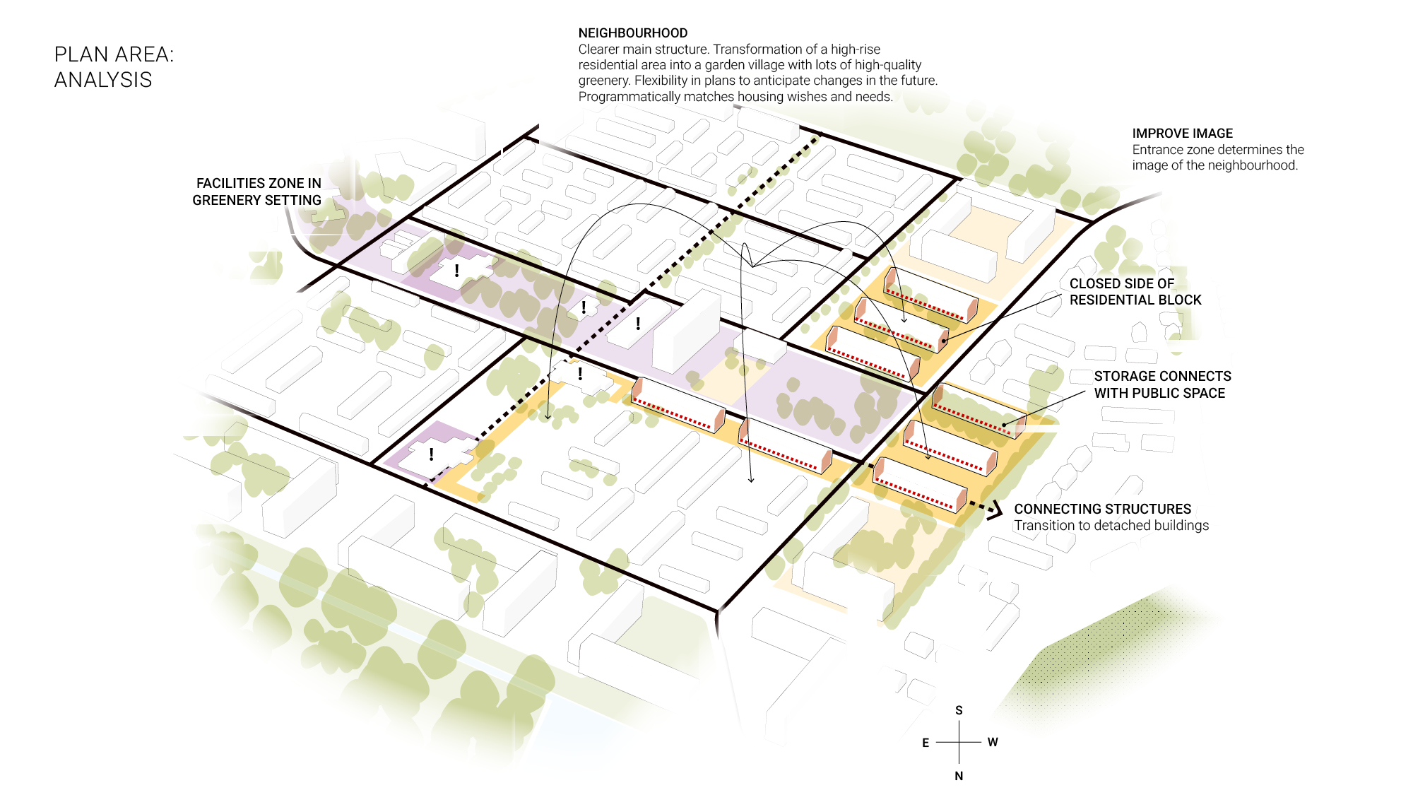
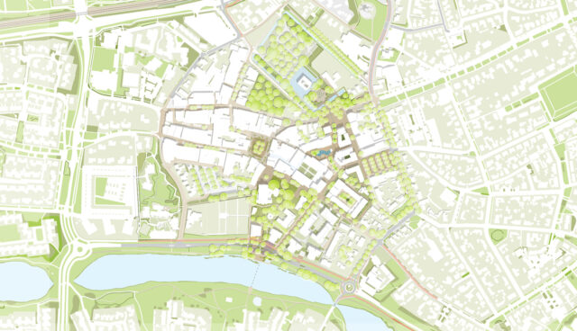
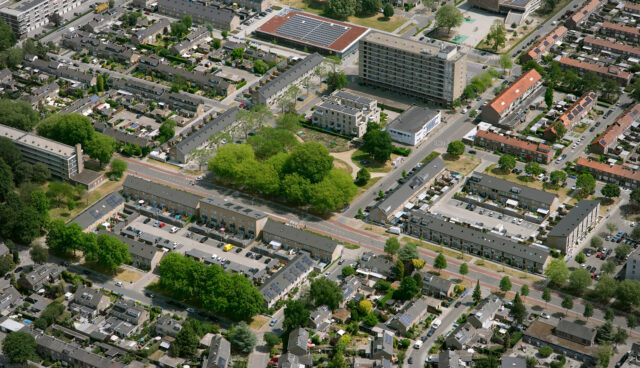
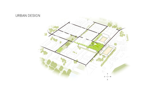
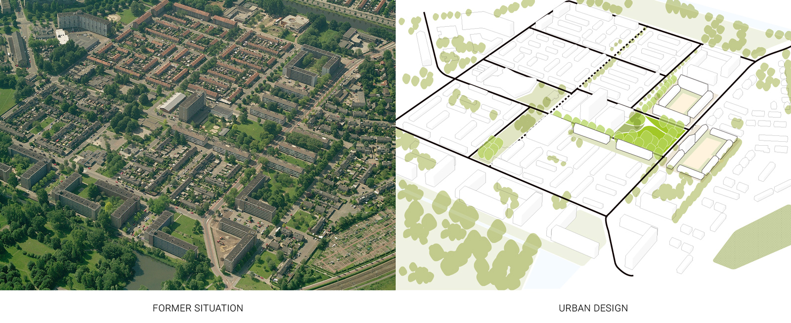
in collaboration with: Stijlgroep Landschap en Stedelijke Ruimte Rotterdam
status: designed in 2008

LIENDERTSEWEG AMERSFOORT

The municipality of Amersfoort faced a major issue around the theme of living. The spatial development possibilities of the city had more or less reached their limit; at the same time, the quality of existing neighbourhoods lagged behind in various aspects. The municipality chose to improve the existing city through restructuring and give attention to the old neighbourhoods. In the Amersfoort neighbourhood of De Liendert, a number of major changes were intended through large-scale restructuring. In this working-class district, with social and economic issues, the municipality wanted to renew the housing stock drastically and in addition give people in the district the possibility of moving to better housing. A park increased more social cohesion by creating a meeting place in the green heart of the district. De Liendert is one of the focus areas within Amersfoort that is being restructured. In the long-term the municipality expects positive economic and social improvements. The plans were implemented between 2007 and 2020. OZ designed the urban plan and the public space, including the new design for the neighbourhood park. OZ was also involved in the vision of the architectural atmosphere and the choice of architect. The new homes were designed by architects Op ten Noort Blijdestein. In the progress to the final designs, stakeholders discussed intention with the local residents. OZ, together with the municipality, corporations and several other advisers, realized a master plan that improves the neighbourhood in all aspects. This involved making a strategic design vision, making a strength weakness analysis, determining the locations for new construction, and designating objects to be demolished. This resulted in a number of sub-projects, including the assignment to restructure the Wiekslag-Liendertsweg-Rietzangerstraat area. For this sub-area, OZ worked out both the urban development plan and the details for the public space. The Liendert in the old situation, was characterized by green structures such as avenues and parks. The former houses were porch houses, the quality of which was so poor that it was decided to demolish them.

The aim of restructuring De Liendert is to create an attractive living climate in the district. Therefore, large-scale restructuring interventions have been proposed:

  • New homes. The outdated houses have been replaced. 108 single-family homes were built, of which 63 in the social rent category, six in the free rental sector and 39 owner-occupied homes.
  • Reinforced green structures. The avenues and parks are interconnected.
  • Renewed park as the social heart of the district. The park at the Rietzangerstraat-Wiekslag-Liendertseweg was renovated while retaining the existing trees. It is a place for different target groups: children play there and adults meet each other there.
  • Improved spatial coherence. The redevelopment and restructuring of the streets and public space ensures an improved spatial cohesion and unity in the green guidance, the building lines, and adjacent buildings. The public space is first designed for pedestrians and only secondarily for the (parked) car. Rest areas or anonymous hangouts outside the social context have been prevented by choice.
  • Connection to the water extraction area. By removing the garages at De Horsten, De Liendert will be linked to the water extraction area.

Due to the spatial changes, the neighbourhood has been given a new image, connected to its environment. In the progress to the design, all parties involved, with residents of the neighbourhood as one of the most important stakeholders, intensively sought the best urban development vision.

Program and routing
The program consists of a school cluster with community centre, care homes with amenities, a shopping area with housing and various housing typologies.

client: Municipality of Amersfoort, De Alliantie housing corporation, Portaal housing corporation
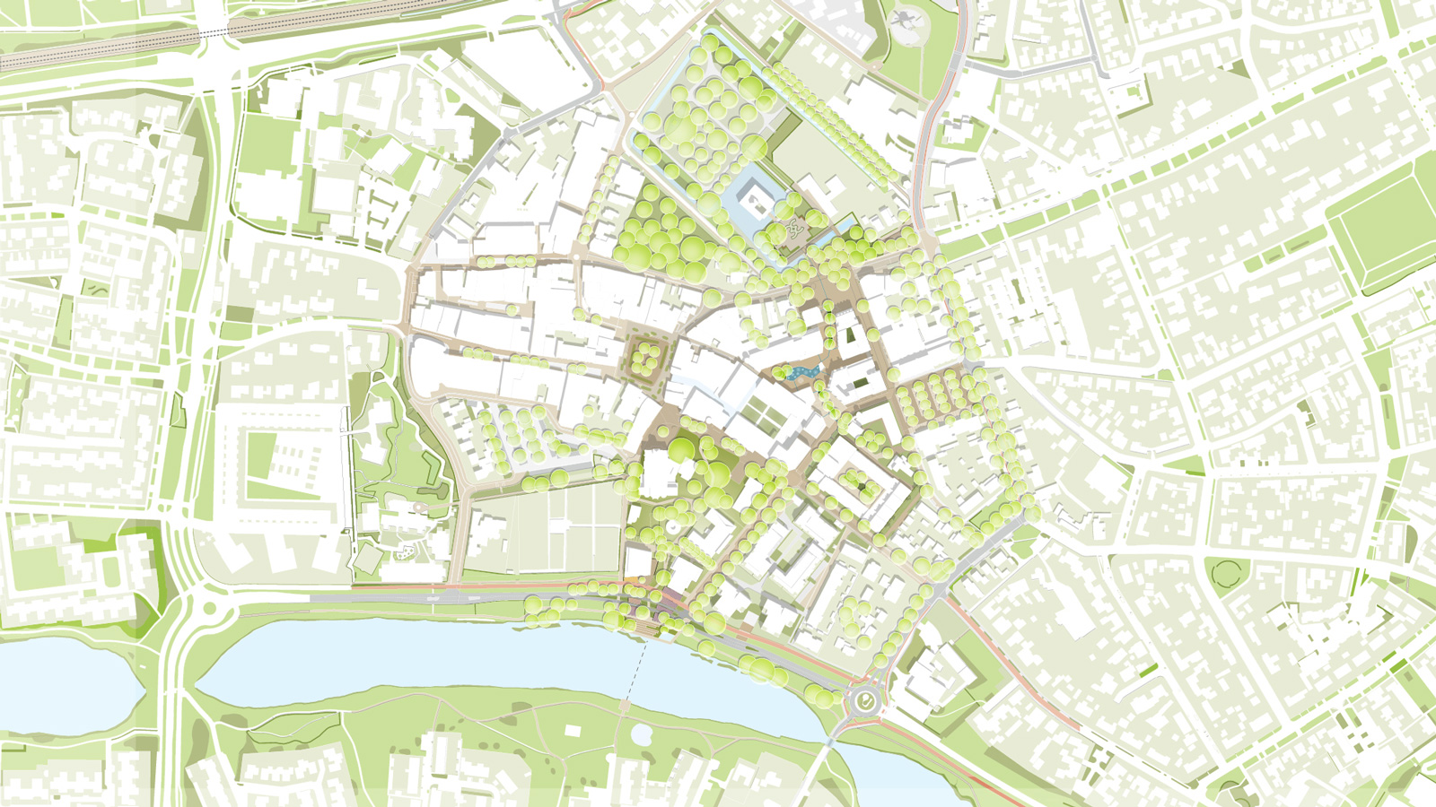
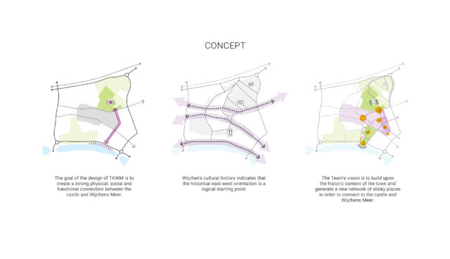
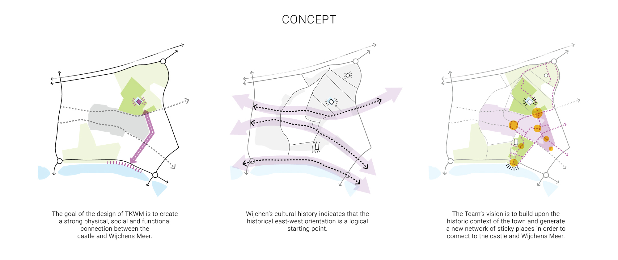
status: The plans were implemented between 2007 and 2020

TUSSEN KASTEEL EN WIJCHENS MEER

The task at hand for Tussen Kasteel and Wijchens Meer (Dutch name for ‘In between the Castle and Lake of Wijchen’) is to connect the two pearls of Wijchen – the castle and the lake – with each other. Main reasons why the municipality chose OZ’s restructuring design: sticky places (places that invite visitors to wander through the center streets), the complete range of housing and commercial spaces, and out of sight parking solutions. This is the result of a dialogue-driven tender between the municipality and tenderers after an intensive two-year process.

The already beautiful village will become even more beautiful and also future-proof through restructuring. The castle and the lake are the two local highlights. Despite their great historical and cultural value they are isolated from each other and the public areas in Wijchen. An absolutely missed opportunity for the municipality which is why it wants to make the connection between the two Wijchen icons and the center. A connection brings many different benefits: an attractive identity, cultural and historical value, a balanced housing program, and the integration of sustainability and innovation. For the village, this project also means that work will be carried out in their center for 5 to 10 years. The center location has a large number of stakeholders that must be taken into account. 

The usp’s of OZ design:

  • Sticky places. OZ presented a network of public spaces such as major and minor streets, with ‘sticky places’ within them. The plan consists of new buildings – residential and commercial – and new or renovated public spaces. They invite the visitor to wander, stay and meet. Image-defining places in this network are the Castle Garden, the Parish Garden and the Lake.
  • Integral approach. The winning team consists of professionals from all construction sectors: energy (transition), mobility, social sustainability and circularity. The design for the public space was done together with landscape architect Houtman+Sander. The initial architectural design by OZ. The winning design will be developed further in the follow-up process, but has already integrated the necessary (local) parties and knowledge into the plan at the initial stage.
  • The local approach. The design is “real Wijchen”, which means that both residents and passers-by will feel at home in Wijchen, with its current village character.
  • Sustainability. Sustainability in the design for Wijchen consists of four components: circularity, the Living Building Challenge, energy and ecology.
  • Phasing. In addition to the design, OZ also advises on smart phasing. The most important pillars of phasing are: keeping the current program accessible at all times and having a balance between investment and yield for the developed party.

From the castle to the water, the four different project locations are located along a winding line that meanders first south-east and then south-west. These are: the Castle Square, Water Square, Tuinstraat, Tuin van Wijchen. Because the new and renovated buildings are connected with new routes and the public space , there is synergy between the four project sites. The phased implementation of the project is expected to take about five years. The four project locations and associated design visions:

  • Castle Square. The design envisions an open view between the sticky places of the Kasteeltuin and the Kasteelplein. The garden space in front of the castle becomes a forecourt with new greenery and stairs along the moat creating a view from the castle to the water and the Castle Square. The stairs are a pleasant place to sit and enjoy the sun. From the Castle Square you have beautiful view of the castle with its moat. Trees ensure a pleasant atmosphere around Kasteelplein and shade in the summer. This square will function as a space for the weekly market and other events. Two new buildings are realized on the Kasteelplein. In line with the informal architecture along Kasteellaan both objects are different, but informal. Both buildings have a raised plinth and vertical windows in order to make contact with the public space. Program is mixed to include housing, commercial space and a café lounge and hotel. These buildings guide the square spatially, and provide the entrance time towards the Waterplein.
  • Water square. The street that connects the Kasteelplein to the Waterplein slowly elevates. Centered along this street are green wedges with low, richly flowering plants and some solitary trees. Building off the existing public space, the bike and car parking is relocated directly below the square and the size of the square is expanded. The Waterplein is given more definition through the surrounding architecture, by creating privacy and wall formation. The new buildings in the square have a “standing” character with vertical openings that strengthen the relationship with the square. A kiosk and water feature in the square makes for a nice onescale and size so that there is no “empty” square. The water artwork on the Waterplein will be a popular place for children, but also for older visitors. Because of the seating elements the water can really be experienced here: a true attraction where young and old meet. The green wedges are also an extension of the water square of the water artwork. Within the square, recreation, living, shopping and working come together and overlap to create a new center for the town.
  • Tuinstraat. The Tuinstraat is a sticky place that introduces more green into the street and creates an intimate interactive atmosphere. The additional green space creates village agriculture and contributes to biodiversity. The amount of pavement is minimized, embracing the ‘living street’ concept and the pedestrian stands central. There will not be a traditional park, but one place with public vegetable gardens that residents use together. The new architecture interacts with the existing context, maintains living on the ground floor, so that there is no anonymous plinth, and still allows individual character.
  • Garden of Wijchen. By making the parish garden publicly accessible and expand south to a new park that extends to the banks of Wijchens Meer the Garden of Wijchen is created. An area that literally establishes a connection between the center and Wijchens Meer. The garden of Wijchen consists of several rooms with large mature trees, passing through a network of walking routes connected to each other. Here you come to enjoy the peace and nature. The new buildings are designed as objects on all sides. So they only have fronts and guide sight lines towards the church and Wijchens Meer. The Garden of Wijchen connects the parish garden with Wijchens Meer. A playful staircase bridges the height difference between Wijchens Meer and the edge of the water.

client: Ter Steege Bouw Vastgoed, Gemeente Wijchen
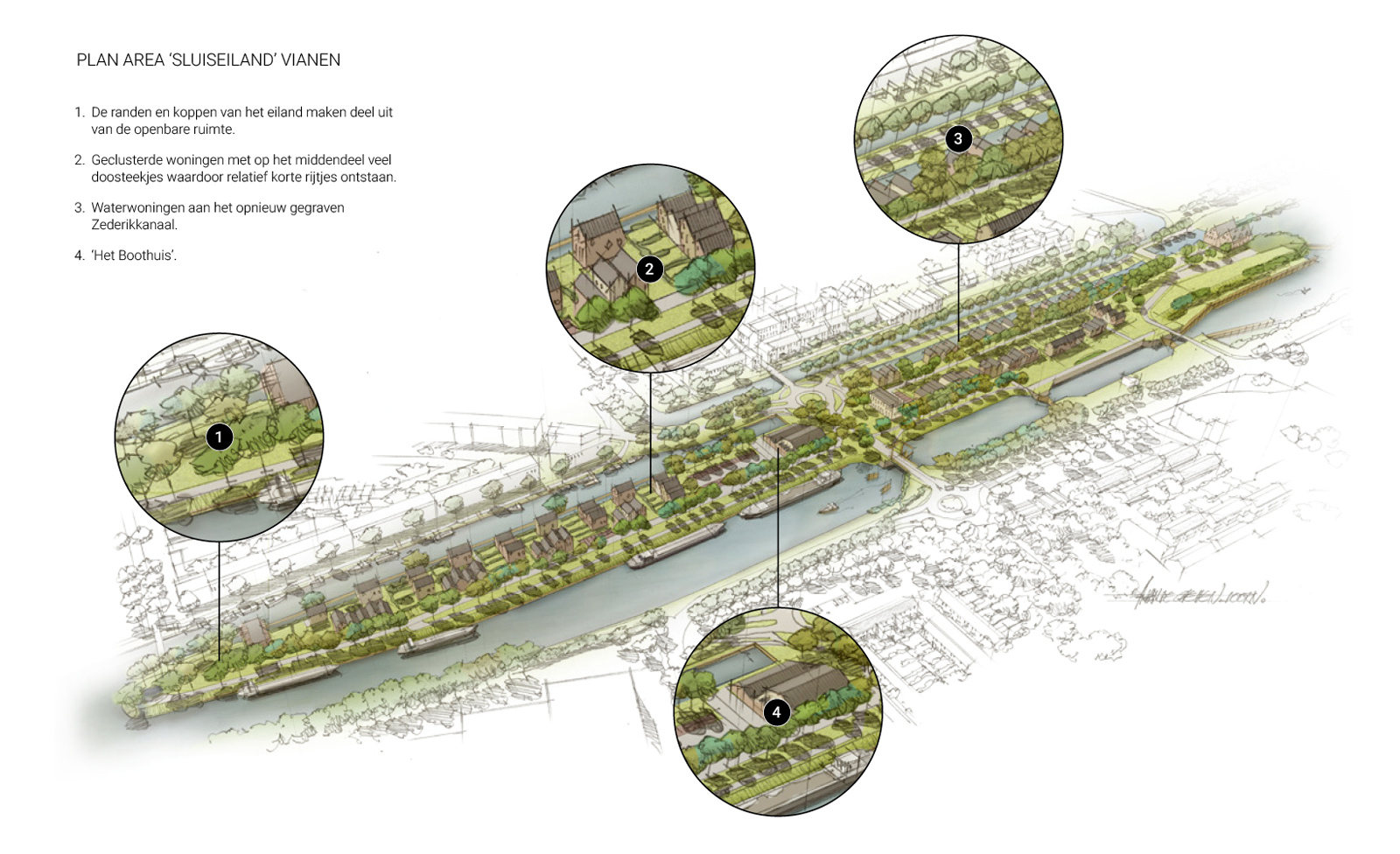
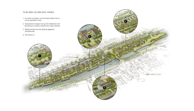
status: designed in 2020

Read more about Tussen Kasteel and Wijchens Meer

SLUISEILAND VIANEN

The municipality of Vianen wants to develop the unique location of ‘Sluis Island’, (Sluiseiland in Dutch). Sluiseiland is a somewhat anonymous strip of land surrounded by water, between two canals and their associated locks. Located near the centre of Vianen, the island now creates a barrier rather than a connection. The municipality set up a tender to develop the area with the following principles: to spark a new impulse to the city centre, the surrounding neighbourhoods and the image of Vianen as a whole. The design, a collaboration between OZ, Bosch Slabbers, VORM and Aalberts made it to the final round of the competition. OZ took contributed to the urban design part of the proposal and designed the homes and other buildings. In our vision, we are improving the location by restructuring and creating connections.

A characteristic feature of the island is its rich history: the area evolved over the course of time as a space created by the construction of two new canals, the lock complex present is a national monument. The island was designed at the time with striking rows and groups of trees and grass meadows. It is intersected and flanked by waterways, quays and dykes. These hydraulic elements determine the identity and visibility of Sluiseiland. Currently, the island is used primarily for parking, however the two parking places break up the spatial coherence between the island and the former Zederikkanaal. The island is also used for recreation activities, such as hiking and outdoor events.

In OZ’s vision, Sluiseiland functions as a connecting park, as an island and a park. How are we going to realize this restructuring ambition? We explain this through the three pillars of island, park and connection:

  • Island. The island is made a true island again as much as possible. We will achieve this by moving parking lots P1 and P2 to one large parking facility near the boathouse and excavating the bed of the old Zederikkanaal. We will then create a canal experience by adding three elements: a bridge in the extension of the Spekdam, a collective greenhouse in the water and a public fishing pier. We have made the old Wilhelmina lock visible again and given it its own lock houses. In our plan, two bridges will be added, strengthening both the island feeling and the connection with west Vianen. In addition, the island atmosphere will be enhanced by keeping the edges of the island public and accessible to everyone. The water around Sluiseiland is thus perceptible.
  • Park & connectivity. Lock Island will be a public park which can also be lived in, by the addition of new housing. The most desirable edges of the park are along the water and the public space here is communal, so intended for everyone. We are also investing in various recreational functions. The residential area is deliberately not enclosed, which creates urban sustainability. We put maximum effort into public accessibility and cohesion.
  • Architecture and housing diversity.In our proposal, as in the centre, we chose individual construction to give a lively palette of appearances. We play with masses, use masonry in different colours, with brick connections and detailing in the grouting. The program has a good mix of ground-level houses, apartments and water houses in various price brackets. A portion of the houses are ‘CPO’ (privately commissioned) built. In total the housing program consists of 117 houses. We are adding facilities to increase the quality of life, the most typical of which is the event area and the market hall at the northern end of the island. Parking spaces will be created in private as well as public spaces. The houses are energy neutral and gas-free.
  • Connection.The design of our restructuring plan encourages interaction between neighbours and people in general via gathering points. The program includes various (neighbourhood) facilities, such as three new public squares to facilitate encounters.

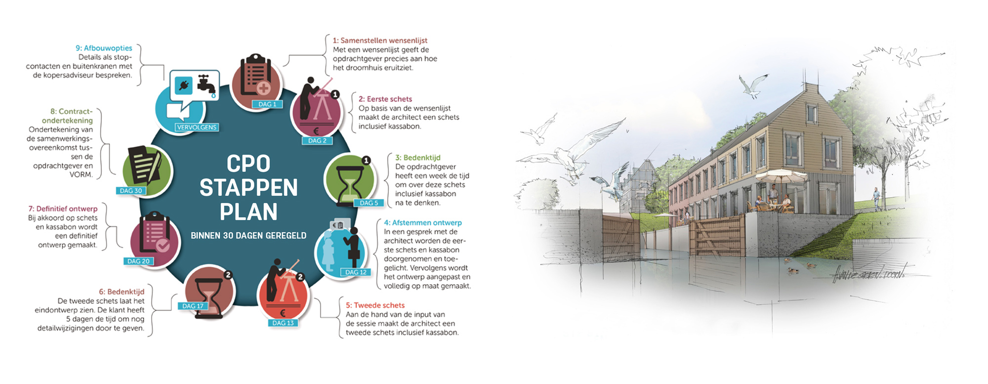
Co-creation & Participation For years, our specific method of development has been interactive, whereby we directly involve the (potential) buyers in the process. We create opportunities together. Organizing workshops and conducting surveys gives us specific market information that adds value to our plans.

client: VORM ontwikkeling BV
status: designed in 2016